I arrived in Jordan with two intellectual Jewish friends who had forgotten to bring a map (If you ever go to travel in Jordan, I don't recommend doing this).
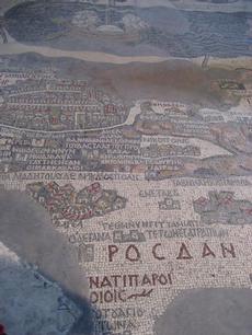
Therefore, it was with great delight that while in Jordan we discovered that the little town of Madaba, about a half hour drive south of Amman, where a legendary 1400 year old Mosaic Map of the Holy Land from the Byzantine era is housed in a modest Greek Orthodox Church. The map is a major tourist attraction since it is the oldest known map of the region, and despite some inaccuracies is regarded as the most exact map of the Holy Land before modern cartography was developed. (In other words, the map was a perfect find for us!)
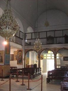
In 746, about 200 years after the mosaic map was constructed, Madaba was largely destroyed by an earthquake and subsequently abandoned. The town was still uninhabited in the early 1880’s when a group of Christians from south of Amman, decided to move there to escape conflict with Muslims in their home town of Karak (a story we've heard before). The new Christian settlers were removing debris from an old church in 1884, in order to build a new one on the site, when they discovered the remains of this huge detailed map by an unknown artist, which they incorporated the surviving fragments into the new St. George’s Church.
The map was made out of two million individual little cubic coloured tiles (known as tesserae) which to me seems like Byzantine era light bright. The map has 157 captions in Greek (since I don't speak Greek, the captions were 'all Greek to me', pardon my pun) depicting all the major biblical sites of the Middle East (covering what is today Lebanon, Jordan, Israel, Palestinian territories, and Egypt).
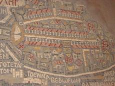
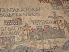
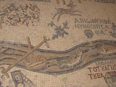
The focus of the map the city of Jerusalem, with its walls, gates, main streets and 36 specific buildings represented, including the Church of the Holy Sepulchre. Since my friends and I were to return to Jerusalem after a week in Jordan, this map theoretically could have been very helpful to us in navigating, except that we couldn't exactly bend down and take the map in the car with us. While others were examining the vivid representations of fish in the Jordan River or of the palm trees around Jericho (which were lovely, see my photos), I was trying to see if the map had any drive through fast food joints listed, or any Roman style lavish public washrooms on route back to Jerusalem, since we would definitely need one of those.
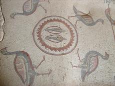
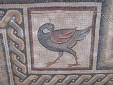
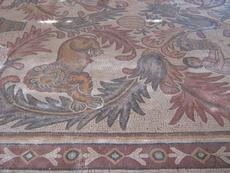
Note that Madaba was first mentioned in the Hebrew Bible as Medeba at the time of the Exodus (Numbers: 21,30; Joshua 13:9), and there are literally, hundreds of other exquisite mosaics from the 5th through the 7th centuries scattered throughout Madaba's homes and homes, some of which can we saw in Madaba's Archaeological park (see photos). My most prominent memory of the Archaeological Park was that the Jordanian guide in reference to a mosaic with Ashkelon on it, said "Ashkelon Palestine", notwithstanding that Ashkelon has been part of the State of Israel since 1948.
Turning back to the mosaic map of the Holy Land in the Greek Orthodox Church, scholars have differing opinions on what the purpose of this map was. Why was this artistic treasure commissioned by Church authorities on the floor of a Christian building in a provincial town of what the Roman Empire? One theory is that it was made to aid pilgrims (like us!) in making their way from one holy place to another. This theory doesn't quite make sense since pilgrims could not take this map with them, and portable maps and local guides were available at the time. Other scholars suggest that the map was designed to represent Moses's vision of the Promised Land when he stood at the top of nearby Mount Nebo, (which was a few minutes’ drive away).
The truth is that I am really not sure what the purpose of this map was, but I did think it might be useful in helping orient us in driving back from Amman to Beit Shean in Israel's Jordan valley, where from there we would drive back to Jerusalem. Luckily, I was able to spend a buck or two and buy a copy of the mosaic map which was being sold as a souvenir. (Although it didn't help much--we still got lost on the drive from Amman to Beit Shean).
We left Madaba after finding some ice cream. I did ask a Madaba shopkeeper what he thought of King Abdullah, and he responded, "You know you aren't supposed to ask me that. I can't answer that," with a big smile. (In Jordan, you don't criticize the King in public ever, or else you could be arrested).
Looking at the Madaba map of Jerusalem, I did think of how it would have been much more relevant the map was for Jordan prior to the 1967 war, when the Hashemite Kingdom controlled East Jerusalem including all of Jerusalem's Old City,which is so carefully depicted in the map. Thinking of 1967, I was reminded of the bitter truth that even after King Hussein had made a pact to join Nassar and the Arab allies, he still would not have entered the war in all likelihood if Nassar had told him the truth that all of the Egyptian air force had been destroyed in the first morning of the war. Nassar, Egyptian military leaders and Egyptian radio betrayed Hussein and lied reporting to him indicating that much of Israel's air force had been destroyed, and that Egypt was winning the war. (One report is that Nassar told Hussein that 70% of the Israeli air force was destroyed)
Just prior to the war, Hussein, who feared that Nassar would try to engineer a coup against him as he had tried to do in the 1950's if he didn't join the war decided to sign a mutual defense treaty with Egypt that gave the Egyptian officers overall command of the Jordanian army. Because of this, as an Arab journalist and analyst based in Washington wrote in Alarbiya in 2012, "Jordan found itself at war by a decision made by Egyptian military leaders in Amman and Cairo even well before the King knew about it."
http://english.alarabiya.net/views/2012/06/18/221354.html
Younes notes that Hussein's secret contacts with Israel started in 1963 in the house of his Jewish family doctor in London, Dr. Emmanuel Herbert “and he could have saved the West Bank, had he listened to his western backers or to the assurances of the Israelis to stay out of the war."
Perhaps most interesting is Younes's conclusion that "The lack of free and independent Arab media and journalists "was a key factor in the 1967 defeat." Arab media outlets and journalists "acted as an extension of the regimes and as their official apologists. They did so by putting the interests of the ruling family or ruling party over and above the interest of the state."
Editor's note: My trip to Jordan was in the spring of 2008.